Welcome to the Lowton Website
Our Email address is [email protected]
If you use anything including text and photographs from any of our websites,
for use on other websites or social media sites, please credit Lowton Websites

Vision Bus have withdrawn the commercial number 588 service
However Diamond North West have taken on the service Below is a link to the daytime timetable. Vision have retained the TfGM supported evening and Sunday service https://www.diamondbuses.com/media/4104/584-588.pdf Click here for 2016 Gingers Egg Run Well Don again scooterists
https://youtu.be/NMnXOtymnMQ Below is our Powerpoint presentation please note some items may have changed since we produced it. Some buildings may have been demolished and redeveloped such as the Civic Halls and St Catherine's Church 
CLICK HERE TO VIEW PRESENTATION
A presentation by lowton website from Lowton Websites On some browsers you may need to click the play button to change slides every time. The button to the right of the play button makes the presentation full screen. The button on the far bottom right takes you to the host site here you will find descriptions to the slides and a link to the Lowton Independent Methodist Church presentation. PLEASE NOTE: The URL's www.lowtonwebsites.co.uk and www.notwol.webs.com are no longer active please use www.lowtonwebsite.weebly.com and the email address: [email protected] _________________________________________________________________________ The whole content of this site is Copyright © 2013 - 2021 Lowton Website, however it is available for none commercial use without charge but we would appreciate the mention of our copyright. About LowtonPlease note the underlined text is linked to Wikipedia pages if you click these you will need to click the back button to return to this site.
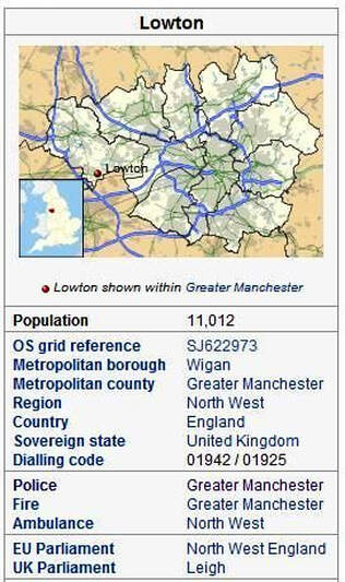
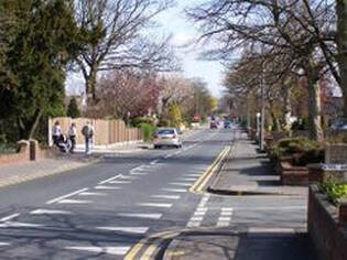
LOWTON is a village within the Metropolitan Borough of Wigan, in Greater Manchester, England. It is around 2 miles (3.2 km) from Leigh, 7 miles (11 km) south of Wigan and 11.0 miles (17.7 km) west of Manchester. The settlement lies across the A580 East Lancashire Road. Historically a part of Lancashire, Lowton's early history is marked by its presence of Byrom Manor, the ancestral home of Byroms, the family that included poet John Byrom, who invented a system of shorthand. Lowton, as a locality, was associated with coal mining and other manufacturing during the time of the industrial revolution given its proximity to several nearby collieries and factories. Lowton has an unclear toponymy: it is from Old English tun "farm, village" with an uncertain first element (The first element is from lhe old English for high point IE Wornoth Low near Stockport is the highest hill in the area, and Lowton is the highest point locally.) A record of the name as Liewetune in 1176 suggests Old English hleowe "lee", although this is not a certain etymology. Lowton was one of the berewicks of the Royal Manor of Newton, later being one of the members of the Barony of Makerfield.[1] Byrom Manor, later to feature the ancestral home of the poet John Byrom and was constructed during the 18th century, is recorded as early as 1212, where the family prospered for centuries. Byrom Hall at one time featured a moat. The Hare and Hounds public house, built in the 17th century, was once used as a place to hold trials of local criminals, including murders In 1830 Parkside, Newton-le-Willows, near Lowton, was the site of the world's first fatal passenger train crash, when Liverpool MP William Huskisson was killed after being hit by George Stephenson's Rocket locomotive during the opening of the Liverpool and Manchester Railway. The former Lowton railway station was used as a resting point for the royal train. Lowton had a toffee factory, along with other sites of heavy industry. In common with many parts of the United Kingdom, many of these factories have now closed and been replaced with some light industry. Between 1894 and 1974, Lowton was part of the Golborne Urban District, in the administrative county of Lancashire. In 1974 as part of the local government reorganisation enacted in the Local Government Act 1972 it became part of Greater Manchester with the boundary at Newton-le-Willows marking the edge of the new county of Merseyside. Lowton comes under the constituency of Leigh and is represented in parliament by the Conservative MP James Grundy (Who has lived in Lowton all his life) Situated on the A580 East Lancashire Road, the village has direct access to the cities of Manchester to the east and Liverpool to the west. From this road, the M6 motorway runs north and south, and the M60 connects with the M62 across the Pennines. The nearest railway station is Newton-le-Willows on the Chester to Manchester Line and Liverpool to Manchester Line. Public transport in Lowton is co-ordinated by Transport for Greater Manchester (TfGM) and is served by buses to Manchester, Wigan, Leigh and Newton-le-Willows. Buses: 34 Lowton/Leigh-Manchester. To the south of Lowton is Highfield Moss, part of which has been designated a Site of Special Scientific Interest. There is an airstrip belonging to Lancs Aero Club situated at the edge of the moss. The 52.6 acres (21.3 ha) site was designated in 1986 for its biological interest. The interest is predominantly mire communities of which it is the best example in Greater Manchester.Education
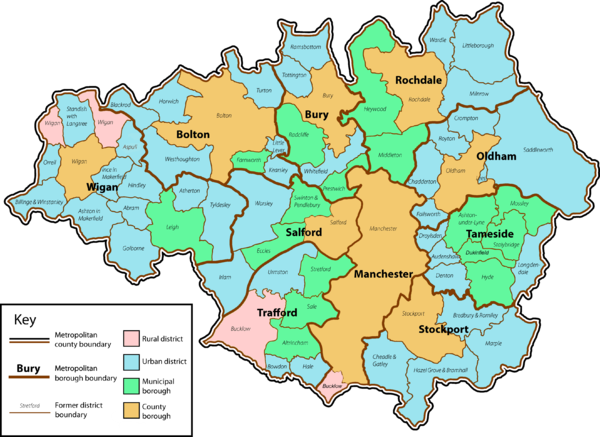
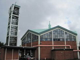
Lowton's churches include two Anglican churches, St Mary's and St Lukes, the Roman Catholic, St Catherine of Siena closed in 2011and now meet at the church of St Catherine and All Saints Golborne, Lowton Independent Methodist Church, a member of the Independent Methodist Connexion, and Lowton Community Church Lane Head Methodist closed in 2010 congregation moved to Heath Street Golborne now renamed Golborne & Lowton Methodist Church in the Sankey Valley Circuit. The churches organise some joint activities including ecumenical services. Their charity work included the Lowton Churches Romania Appeal, formed after the collapse of the Communist regime in Romania in 1990. It supported an orphanage in Lugoj but its remit has expanded to include several projects in Romania. Lowton is the location for Golborne Sports and Social Club which participates in local Football and Cricket leagues. Other nearby sports teams include Golborne Parkside RLFC, Leigh RUFC and Leigh United FC. Below is a map of Greater Manchester |


Lowton East Neighbourhood Development Forum
Details and Information about the HS2 rail line, Kenyon Hall Air Strip and Over development issues can be found on the LENDF website click the above link. 
A similar group to Lendf but covering the Lowton West part of the Golborne and Lowton West electoral Ward.
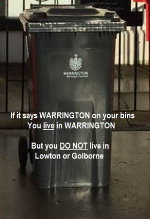
www.lowtonwestresidents.co.uk ____________________________ Lowton Website is independent and has no connection with LENDF, LWRA, OLV or any of the organisations mentioned or linked. _______________________________ OUR LOCAL VOICE http://ourlocalvoice.co.uk/ ______________________________ Website Code: Lowton @ C14 WHERE DO WE LIVE ?
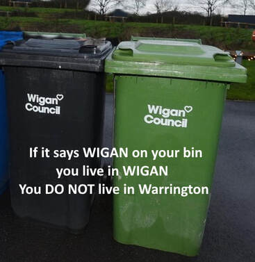
Wigan or Warrington To avoid confusion look what it says on your wheelie bins
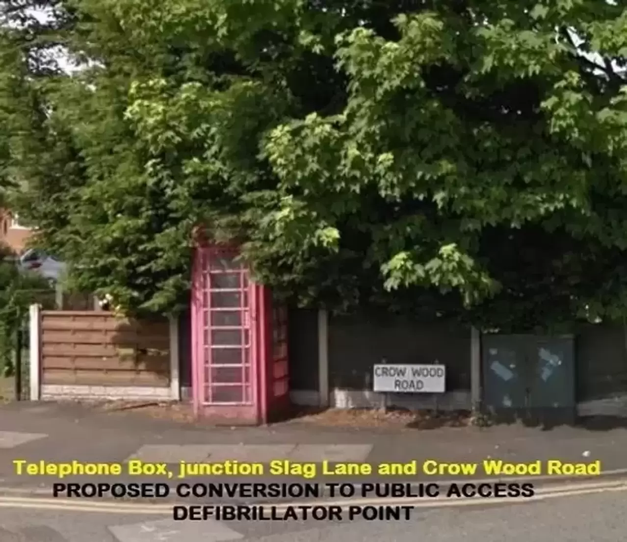
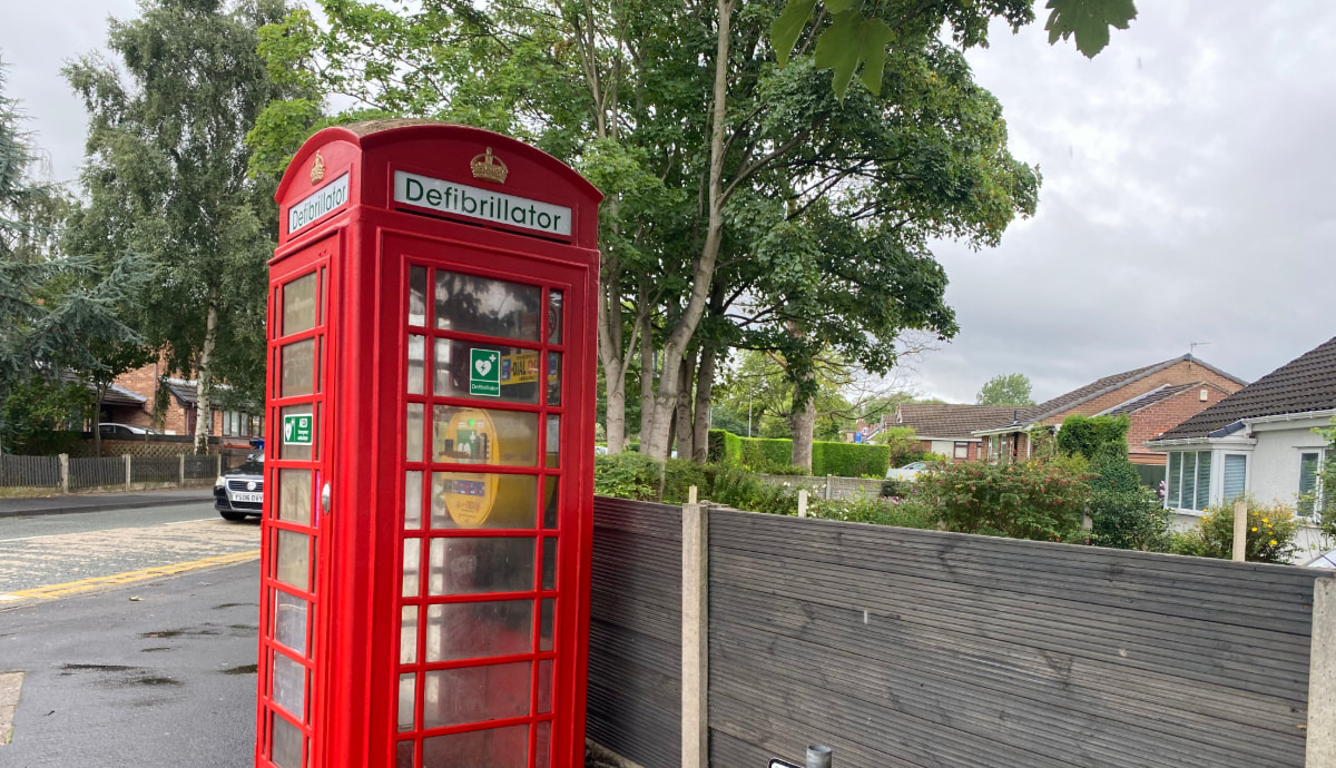
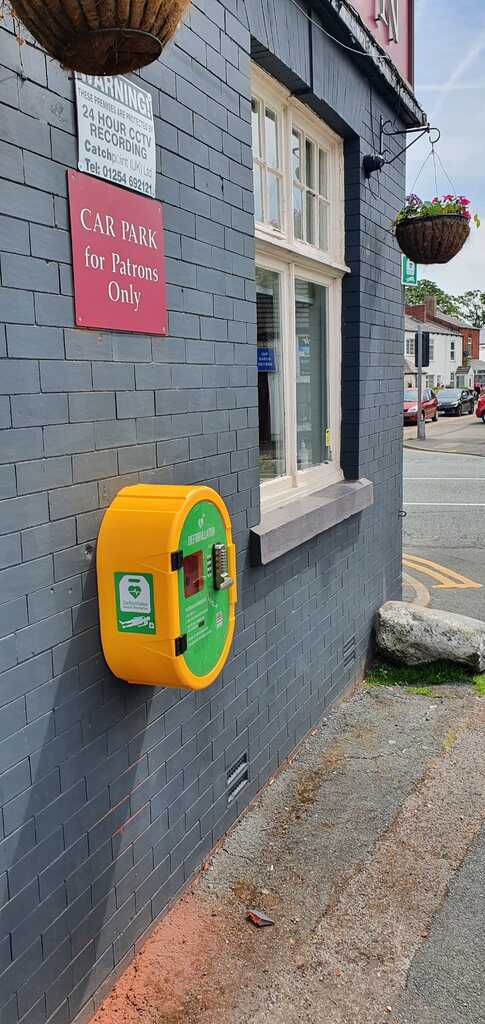
Good News ! another Public Access Defibrillator is now live in Lowton this one funded by Red Lion Bowling Club, Located on the outside wall at The Red Lion Public House, Lane Head
|
SERVICES
To update this information please contact the webmaster This web site does not have any connection with or endorse any of the services or organisations listed on this page the information is provided for information only. LOCAL INFORMATION Local Authority; Wigan MBC Tel: 01942 244991 Council Offices; Wigan and Leigh. The Golborne office is now closed Payments can be made at Post offices and Pay Point outlets LOCAL COUNCILORS: Golborne and Lowton West ward and the Lowton East Wards, are served by members of The Labour Party and Conservative Party. Member of Parliament: James Grundy (Conservative) Police: Greater Manchester Police L Division Tel 0161: 872 5050 Passenger Transport: TfGM. Tel: 0161 228 7811 Local Schools: Lowton Church of England High School. Tel: 01942 767040 Golborne High School Tel: 01942 726842 St.Luke's Cof E Primary School Tel: 01942 201140 Lowton West Primary School Tel: 01942 724864 St.Catherines RC Primary School Tel: 01942 671528 Lowton J & I School Tel: 01942 673213 St.Mary's CofE Primary School Tel: 01942 769716 Gilded Hollins Primary School: 01942 678903 Bus Services: 24th September 2023 All services now part of Bee Network Local Services See Tfgm or Bee Network for details The Post Office: Inside Bargain Booze at St Luke's Londis shop on Newton Road (Near the Civic Hall) If you find it difficult to get to or park on Newton Road we would remind you that you can Tax your car at the HEATH STREET Post Office in Golborne with off street parking and that there is a post office located in the Foyer of Golborne ASDA Golborne. Car tax is now available on line. Public Houses and Residential Hotels: Rams Head, Slag Lane Food Hare and Hounds, Golborne Road / Sizzling Pub Travellers Rest, Newton Road Food Red Lion, Newton Road - RES Church Inn, Newton Road Shepherds Inn, Newton Road, Stone Cross, East Lancs Road (Next to McDonald’s) / Premier Inn Kings Arms – Lowton Village Miller & Carter / Travel Lodge Local Radio: Wish FM 102.4 (Wigan) Wire FM 107.2 (Warrington) 1st September 2020 Wish a d Wire have merged with a number of other stations to form Greatest hits radio Television: BBC 1 North West BBC 2 North West Granada ITV1 Channels 4 and 5 and all the regional Freeview channels The above stations and most main FM radio programmes are Transmitted from the Winter Hill mast at Bolton visible throughout the area S4C, HTV Wales and Yorkshire may be available with appropriate aerial Good DAB reception from at least 4 multiplexes Cable TV, Telephone and Internet ISP Virgin Media (Telewest - Blueyonder) BT services also available VONAGE broadband telephone services are worth looking at numbers available on many exchanges. Telephone Dialing Codes: 01942 (Ashton-in-Makerfield / Leigh / Wigan) South of the A580 some numbers may be on the Newton exchange 01925 Cellular Telephones: All networks available Hospitals: Royal Albert Edward Infirmary Wigan Tel: 01942 244000 A & E Leigh Infirmary Tel: 01942 672333 Minor injuries Unit A & E also available at Bolton Royal and Warrington General Petrol Stations: Texaco East Lancashire Road, Lane Head Asda Golborne Shell Haydock Island (A580) Youth Club, and Pensioners Club: Newton Road Doctors: Newton Road, Lowton Tel: 01942 673962 / 605135 Slag Lane Lowton Braithwaite Road, Lowton Tel: 01942 718221 Dentists: 7a Stone Cross Lane Tel: 01942 722224 71a Church Lane Lowton Tel: 01942 726494 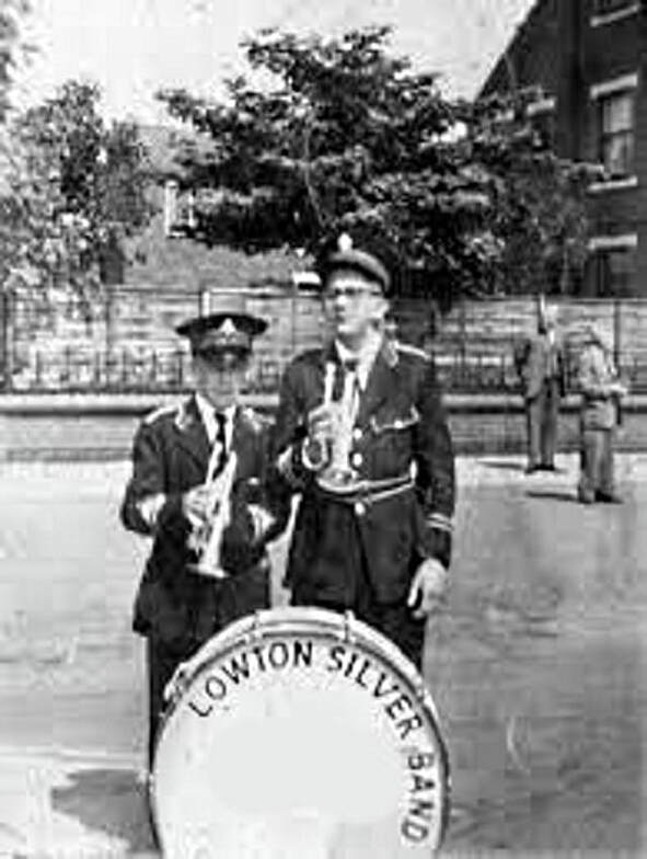
Byrom Wood is a tranquil but popular area of community woodland, managed by the Forestry Commission.
Traffic free, it is enjoyed by families, dog walkers, cyclists, horse riders and joggers whatever the weather. The surfaced paths around the site make it an easy place to navigate on foot. Wildflowers including orchids make a colourful display in spring and summer whilst birds can be seen throughout the year. Winter thrushes such as Fieldfare and Redwings can be seen feeding on berries replacing the summer warblers such as willow and grasshopper warbler. Other wildlife has started to be seen in this area, most recently the roe deer. Buzzards have been seen in the area and the developing habitat here encourages a wide range of nesting birds, including woodcock and grey partridge, also an abundance of brightly coloured insects. Newly sown wildflower meadows full of ragged robin, vetches and oxeye daisy provide food and shelter for the resident wildlife. Until recently Byrom Wood was mixed farmland. Woodland creation, open wildflower meadows and a circular trail are helping to transform the area. There are footpaths and conveniently located benches to admire the views and take in the wildlife that the wood offers. Byrom Wood is close to Pennington Flash Country Park and nearby is Wigan Flashes Nature Reserve. Access is available from the Leeds Liverpool Canal towpath and the surrounding Public Rights of Way network. The nearest car parks are at Dover Lock and Plank Lane (adjacent the swing bridge). Facilities
|
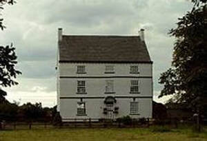
BYROM HALL
INDEPENDENT METHODIST CHURCH

MILLER & CARTER (Lane Head)
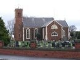
ST LIKE'S C of E CHURCH
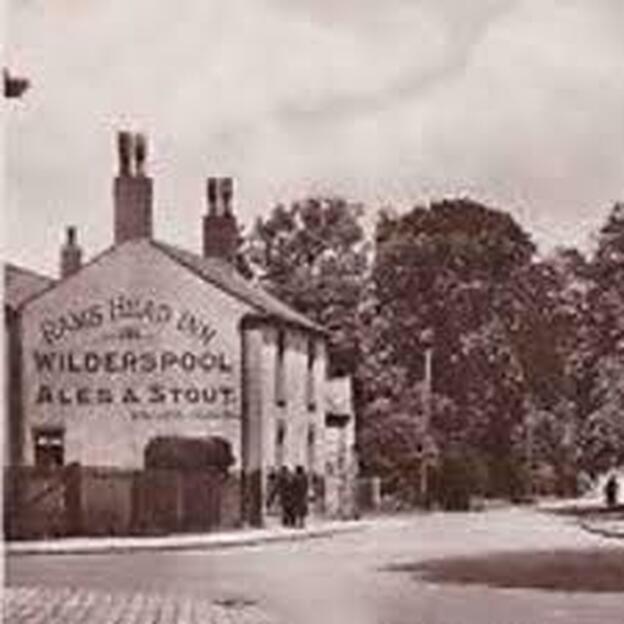
RAMS HEAD
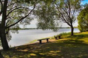
THE FLASH COUNTRY PARK
SLAG LANE
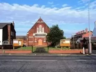
ST.CATHERINES RC CHURCH
CLOSED 2011 Now demolished ______________________________________We would be pleased to receive any photographs of Lowton Silver Band, The Paramount Ballroom Newton Road, and George Ashton's house that was in the area of the Rainbow House or the Co-op stores on Church Lane. Please email us at [email protected] Website Code Lowton @ C14
Last Updated 24th April 2023 Copyright © 2020 Lowton Website
|


BEFORE AND AFTER